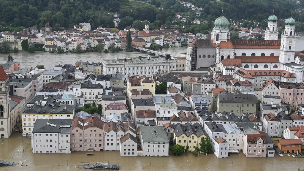
Whether or not our country will end up on the front line of storms similar to the anticyclone sweeping through Germany is merely a matter of chance. At the end of May, even historically speaking, an anticyclone of unusual size and strength formed near the British Isles. This phenomenon is unusual at this time of year, but with climate change it may become a trend.
At the end of May, very serious storms and rains hit the central part of Europe, especially Germany – and inland we were only aware of the fact that the Danube was in flood, but fortunately no serious problems occurred. The background weather phenomenon is, on the one hand, unusual, and on the other hand, it can come together at any time in such a way that we get the best of us.
It is a major anticyclone, with pressure in its central region reaching 1,037 hectopascals, a record for this time of year. It settled over the western part of our continent, drawing cold Arctic air from the north, which met the slightly humid air of the Mediterranean region, wreaking havoc with great force on the northern slopes of the Alps in Austria and Germany for several days. . An anticyclone, even a huge one, isn't very exciting, but the whole thing could be put like this:
About the background of the process Laszlo Molnar Meteorologist, A Kiderul.hu We asked his colleague.
The atmosphere receives excess energy
We must start with the fact that the main driver of atmospheric processes is the temperature difference between the equator and the North Pole in the Northern Hemisphere. In winter, this is much greater than in summer, because due to the tilt of the Earth's axis of rotation, the northern regions are also exposed to solar radiation at a much greater angle during the summer.
The energy of atmospheric phenomena is provided by offsetting this thermal differential, approximately one-third by seawater and two-thirds by air.
Laszlo Molnar explains to 24.hu.
Narrowing the circle to the Atlantic Ocean, the Gulf Stream transports the warm waters of the tropics northward like a giant river into the ocean. Along the way, it gradually cools, slowly transferring its energy to the air, while one of its branches descends near the Canary Islands and heads south, while the other reaches the northern tip of Scandinavia. The last is the North Atlantic Current, which takes the lion's share of the balanced heat exchange.
The released energy creates weather phenomena such as anticyclones that rotate clockwise and are up to five thousand kilometers in diameter. In winter, when the temperature difference between the equator and the North Pole is the most significant, the energy of cyclones and anticyclones is logically greater than in summer, when they have to balance much less energy. The “strength” of an anticyclone is demonstrated by the prevailing air pressure at its center, which averages about 1,040 hectopascals in winter and 1,020 hectopascals in summer.
This is the normal state, based on which you can understand why the anticyclone at the end of May had a historic magnitude of 1037 hectopascals, not to mention the floods it caused.
In this case, it is filled with water
Let's see why we mentioned climate change as a root cause. The North Atlantic Current has weakened significantly, and its water production has decreased by 15-20 percent in the last two decades, the two main reasons being the temperature difference between the equator and the previously mentioned North Pole and the melting of the Greenland ice sheet: a large amount of fresh water causes the “premature” fall For warm salty water. This still requires energy to equalize, but it is transferred to the air, which has much lower specific heat compared to water (the specific heat of a unit volume of air is about 3,200 times lower than that of the same volume of water).
And why does it cause such a fuss in spring and early summer when we consider “the same” to be completely normal in winter? Here too the answer lies in temperature, and more precisely in the ability of air to hold water, which increases with temperature. Just for example, while air at 5°C can contain a maximum of 7 grams of water per cubic meter in the form of water vapor, the same amount of air at 25°C actually contains 23 grams. Above this amount, the so-called dew point is exceeded, and the vapor condenses, meaning rain falls from the clouds.
Therefore, in winter, a large pressure difference between cyclones and anticyclones can be associated with gusty winds, but the cold air is unable to transport enough water for a large amount of precipitation. But the situation is different in the summer, when a huge amount of steam falls in the form of heavy rain due to the huge temperature contrast caused by the record-breaking anticyclone.
The atmospheric physics explanation for this phenomenon therefore supports the fact that with climate change, increasingly severe anticyclones can form in spring and early summer. When atmospheric pressure exceeds 1030 hectopascals in the British Isles region in May or June, we can be almost certain that flooding will occur somewhere in Central Europe in connection with this. Not later – at least for now – because as we move into the warm season, the temperature difference between north and south decreases. But the bad news is that if one of these violent hurricanes moved just a few hundred kilometers to the east, our country would immediately be on the front line.


